Pine trail in Mazovian National Park

Pine trail in Mazovian National Park

MARKINGS: No signs, partially black and blue hiking trail. PUBLIC COMMUNICATION: Train to Otwock. For more than a century, Varsovians have enjoyed relaxing in the Otwock area. The area is considered the green lungs of the capital for good reason. Thousands of years ago, on the dune terrace of the Vistula River, the wind piled up the dunes, which - for lowland Mazovia - are quite large hills. They are overgrown with pine forests. Between the dunes, marshy depressions have formed, filled by peat. Railroad station in Otwock From the modernistic-secession building of the railroad station go west. From under the viaduct you will exit onto the somewhat chaotic Independence Square. Turn left onto Andriolli Street. After a few minutes of driving you will realize,...That - for the middle of the city - there are surprisingly many pine trees growing along the streets. At the intersection of Andriollego and Narutowicza streets, turn left. Right next to it is a building worth visiting. Museum of Otwock Land The museum is located in a small villa Soplicowka at 2 Narutowicza St. (Contact : tel. (22) 788 15 45). Watching the exhibition, you will learn about the nature and history of the region. Return to Andriollego Street and drive to the next block. There turn west, following the signpost indicating the way to the cemetery. Old Jewish Cemetery In a young forest on the dune sands, by the old road from Pogorzela to Karczew lies an old Jewish cemetery. Before the war Jews constituted 3/4 of the permanent population of Otwock. In 1940 the Nazis established a ghetto in the town, which was liquidated two years later. From the cemetery, continue west along a dirt road among the pines. At the edge of the forest your road will merge with the much wider, so-called Red Road. You enter Karczew from the side of the industrial district. Turn left into Armii Krajowej Street, which will take you to the center of the town. Karczew From the church take Żaboklickiego Street southwest. At the intersection with Częstochowska Street, a nice roadside chapel from the 18th century draws your attention. The asphalt ends at the cemetery. Continue among the fields towards the buildings of the poultry farm, visible from afar. Here again the paved surface will appear. The road leads through the buildings of the village of Janow. After a while you will pass a junction with a road leading deep into the forest, which all the time closes the horizon on your left hand. A kilometer further you will cross a bridge over the Bielinski Canal draining the marshes in the Vistula Valley and leave for the village of Brzezinka. The road bends sharply to the right, and after a few hundred meters to the left. All the time you are driving among loosely scattered buildings. Lukowiec Before the village begins for good, the road bends sharply to the left. You on the curve head to the right. The unpaved road leads through meadows toward the already close forest. Once again you will pass over the Bielinski Canal. Beyond the water, the road reaches the wall of the forest and then plunges into its dark, marshy interior. After about a kilometer, the terrain will begin to rise, the ground around will become sandy, and alders will give way to pines. You have entered the higher dune terrace of the Vistula valley. Forest Beyond the sandy rise, buildings squeeze into the forest. This is the far outpost of Celestynów. Although the asphalt encourages you to drive towards the town, turn left and pedal further through the forest. Yellow signs will join your path for a while. Let them run their route, and ride north all the way by yourself. After a distance of 1.5 km you will enter a vast clearing, and after a while you will find yourself among the buildings of Dąbrówka. Dąbrówka Village stretches along the undulating edge of the Garwolin Plain. The slope is cut by small valleys. Turn left into Karczewska Street. Soon houses give way to fields, after another kilometer you will be in the forest again. The road gradually becomes sandy. A gentle uphill brings you to the hill of Dabrowska Gora. Dąbrowiecka Góra From the color of the sand that builds it, the dune is also called White Mountain. If you want to feel like you're in the desert for a while, dive to the right of the road, on the west side of the hill. The gentle descent ends at a junction of roads and trails. If you've had enough, turn right and you'll reach the station in Pogorzela Warszawska. However, we encourage you to drive straight ahead, following the signs of the black trail leading towards Otwock. Initially, you are driving along a very wide forest road. A kilometer farther the trail turns left and, keying through the forest firebreaks, leads in the shade of birches and pines. Base "Torfy" In the old forester's lodge an ecological education center of the Mazovian Landscape Park has been arranged (Karczew, 2 Torfy Street, tel. (22) 7888087). By prior arrangement, didactic classes for schools and other organized groups are organized here. The biggest attraction of the base is the motherlode, established in 1998. Animals that need help for various reasons find shelter here. Continue following the black signs, which soon turn left, into a wide forest duct leading along the edge of the "Peats" reserve. The trail is accompanied by boards of a forest nature trail. After eight hundred meters you will reach a viewing platform. Reserve "Na Torfach" A belt of wet peat bogs stretches along the Vistula valley - from the area of Osieck to Otwock. Most of the marshes have been drained, but here you can still enjoy the charming landscape of the bog. The lake you are standing on, contrary to appearances, was not created by nature. The depression was created as a result of peat mining. Return along the duct towards the forester's lodge, cross the intersection of forest roads and head northwest towards the nearby town of Otwock. A blue hiking trail will join your route, and moments later a villa-like development will appear between the pine trees. Soplicowo You enter Otwock through one of the prettiest settlements.The blue trail wrenches through narrow streets, and then Poniatowskiego Street, and then Filipowicza Street and Armii Krajowej Street leads to the railroad station you already know.


    Feedback

  • Is it possible to print this route somehow ?

    ~domis23 • 29.07.2015
  • Lack of any signage,poor description, but for a Sunday stroll can be recommended ;)
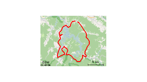
    michal-matuszewski • 19.06.2012
  • I recommend the Peat Lake - something beautiful!!!

    anna-kalaska • 25.08.2011

Map

This route does not yet have a rating.
2/5
Difficulty of the route
32.53
Kilometers